Wednesday, October 11, 2017

California Gold Country Visit Cut Short by Wildfires

Our drive from Chico to Grass Valley took us in to the foothills of the Sierra Nevada range at about 2,500 feet of elevation and slightly cooler temps. We stayed at the Nevada County Fairgrounds RV Park, which at $40/night is one of the less expensive RV parks in the area. This is California's gold rush country, a popular tourist destination due to all the history and scenic beauty the area offers.

A beautiful evening walk around the pond adjacent to the fairgrounds RV park.

We arrived on a Saturday and discovered a number of events taking place at the extensive and beautiful fairgrounds. There was an International Harvester Truck Show, a Veterans Stand Down and a Gem and Mineral Show.

Good old International Harvesters!

Gold-bearing quartz was discovered in Grass Valley, CA in 1850 which led to the era of hardrock (underground) mining. Today Grass Valley and neighboring Nevada City are historical gems full of wonderful old buildings and rich mining history.

Lots of beautiful, well preserved historic buildings in downtown Grass Valley.

Gorgeous mural detail in Grass Valley.

Today Nevada City has about 3,000 inhabitants, down from the boomtown population of 10,000 in the mid 1800's. Only five miles from Grass Valley, Nevada City is just as historically beautiful and its downtown has slightly more upscale shops and an edgier vibe.


One of the largest historical sites in the area is Empire Mine State Historic Park. The Empire Mine was once California's richest gold-producing mine and was active for almost 100 years. It has 367 miles of mine shafts, up to 11,000 feet deep. The park's visitor center has an impressive scale model of the entire mine along with a detailed audio description of the mine's evolution.

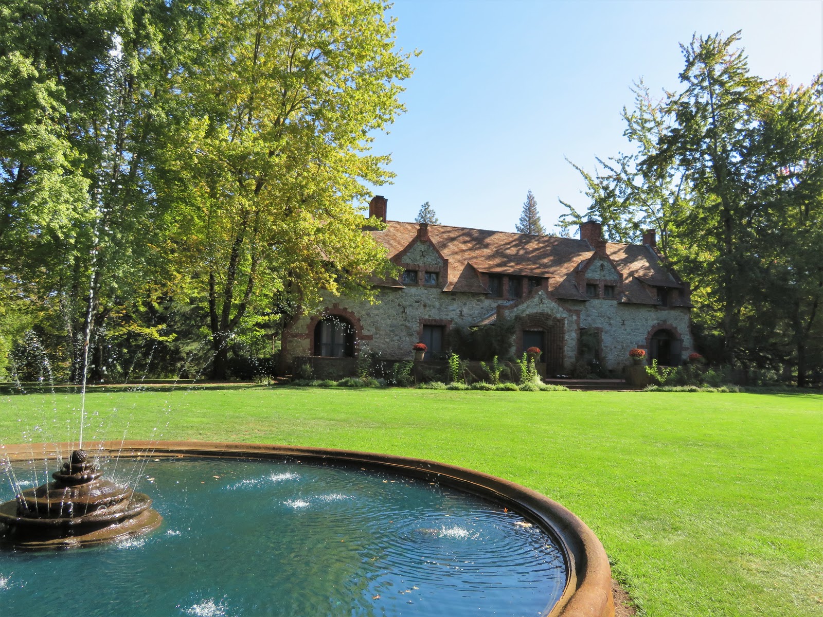
Though mining began at Empire around 1850, the mine did not begin to prosper until William Bourn, Sr. acquired a controlling interest in 1869. His son, William Bourn, Jr., later brought the mine into another profitable era and also built a grand "cottage" and formal gardens on the site for his family.

The cottage and mine sites are enclosed in a fee area, but there are also miles of trails in the state park that are accessible for free. Dogs are allowed on all park grounds.

The Bourn's cottage was one of several homes the family owned.

The formal gardens are lovely, and would have been a dramatic contrast to the adjacent mine grounds.


The mine's administrative buildings.


Demonstrations happening in the blacksmith building. 

Lots of equipment on display depicting the evolution of mining over many decades.

I remember seeing an "extreme" fire danger warning sign as we arrived in Grass Valley and with the hot dry weather and increasing winds we knew to be on the lookout for fire. On our second night the wind picked up dramatically and when Hans looked outside at midnight he saw our chairs being blown about. When he went outside to gather them he saw a large fire burning across the road from the RV park, about 100 yards from us. When he called 911 he was told help was already en route.

We quickly packed up the RV, hitched up to the truck and sat in the truck watching the horror unfold in front of us. If the wind were to change direction we needed to leave immediately...the Ponderosa pines between us and the fire would be a tinder box.

Over the next four hours we watched the wind ebb and flow, fortunately for us continuing to blow in a SW direction, keeping the fire away from us. We watched two buildings, though right next to each other, burn up about an hour apart. We saw giant Ponderosa pines explode into flaming torches. We heard dozens of explosions, probably propane tanks, fuel tanks, and other combustible items as the fire moved SW fueled by the wind. We saw a broken power line sparking on the ground. We saw horses being led by flashlight around the pond to the fairgrounds stables. We saw dozens of evacuees heading north out of the danger zone and dozens of first responder vehicles heading south into the fire zone.

The view from our RV.

Zoom of a building engulfed in flames.

By 6am the fire was contained and had burned about 200 acres. Another larger fire was burning about 10 miles west of us. Over the course of the morning the fairgrounds where we were staying was designated an evacuation point for animals and a staging area for CalFire.

We learned the fire was started by the broken power line we had seen the night before...right across the street from our campsite. With no power, smoke beginning to settle in the area, and lots of displaced people and animals and first responders descending on the fairgrounds it was time for us to move on.

We were so grateful to have suffered only a sleepless, scary night...so many other people are dealing with fear and devastating loss in the many fires across northern California.

Morning view of the two buildings that burned down overnight.

This is where the fire started, you can see a dangled cut power line on the left pole.


Tuesday, October 10, 2017

Beer, Hiking and Disc Golf in Chico, CA

Sierra Nevada Pale Ale has long been a go-to favorite for Hans so it was only logical for us to route through Chico, CA on our way to the east side of the Sierra Nevada range. We arrived to Almond Tree RV Park in Chico at noon with plenty of time to set up camp and relax at bit before our 3pm tour of the brewery. The tours are popular so reservations are a good idea.

Sierra Nevada Brewing is the third largest craft brewer and seventh largest brewing company in the US. Solely owned by one person, Ken Grossman, the plant is a model of sustainability and was named Green Business of the Year by the EPA in 2010. They have the largest privately owned solar array in the country, and they are installing several Tesla batteries to harness the energy produced during down times (the weekends) for use during the week.

We've been on numerous brewery tours and the brewing process is similar at every company, so the interesting part of the tour for us is to learn the history of the company and enjoy the free tastings. The brewery was founded in 1979, long before the craft beer phenomenon took off, and had a lot of growing pains along the way, including the bargain purchase of a 100 barrel brewhouse from Germany that cost 10 times more to ship to the US putting the fledgling company into serious debt.

This was a great tour, with a healthy amount of free tastings included. We started off with a sample of the flagship Sierra Nevada Pale Ale and ended the tour with tastes of seven additional brews. Afterwards we had a tasty pizza and salad at the onsite restaurant which had an extensive tap list with many that are available nowhere else including the one we shared, Ezo IPA, brewed with Asian hops with flavors of coconut, lime and lemongrass.

Goofing around in the hop room.

These small brew kettles are filled with experimental beers, most never make it to the public.

The brews we tasted are listed on the left, that 10.4% ABV Narwhal was tasty but potent!

Bidwell Park is the crown jewel of Chico. Established in 1905, it is currently more than 3,600 acres, over 11 miles long, and is the 25th largest city park in the US. Lower Bidwell Park is in the heart of the city and includes miles of paved trail and green parks and playgrounds. Big Chico Creek connects Lower to Upper Bidwell Park which has a golf course and disc golf course, swimming holes and many miles of gravel and natural trails on multiple levels up a canyon NE of town.

Chico is situated in the fertile Sacramento River Valley, nestled against the foothills of the Cascade range to the north and the Sierra Nevada range to the south. Upper Bidwell Park follows a canyon formed by millions of years of volcanic activity and Big Chico Creek cuts through the Lovejoy Basalt flow which originated from a volcano near what is now Susanville, about 100 miles NW of Chico.

We hiked an awesome 9 mile loop in Upper Bidwell that featured fantastic views into Big Chico Canyon from the north rim plus incredible close up views of the Lovejoy Basalt flow and Big Chico Creek. The sparsely treed gray pine and oak savannahs we walked through were an interesting change from our deep green summer in Oregon and we read that the wildflower displays in the spring are not to be missed.

We parked in the valley below and immediately climbed to the top of the ridge,
then continued along the basalt rim overlooking the canyon.
Big Chico Creek flows through the narrow, dark line at the bottom of the valley.
We saw dozens of vultures flying across the valley, more than we've ever seen anywhere in our travels.
This fine specimen was thoroughly enjoying the very warm morning sun (approaching 80 degrees).


After about four miles on the ridge top we dropped down to the valley and took the Yahi trail overlooking Big Chico Creek.
Dramatic basalt formations lined the sides of the creek bed.

We loved the oak studded golden grass covered savannah, so different from the deep green forests of our summer.

Though relatively flat and easy, the Yahi trail was quite rough due to the chunky basalt underfoot.
Rounded humps of basalt became more prominent as we continued down canyon. 

A turn in the creek bed provided a stunning view into the channel cut by Big Chico Creek.

Looking up at the ridge we had traveled earlier.

Big Chico Creek looks inviting for swimming in this hot summer climate,
but access is severely limited in the upper reaches of the canyon.

The last mile or so of trail brought us down to the water level and we saw a lot of beautiful swimming holes
that are probably packed with locals on summer weekends.
This area seems to have been developed a long time ago for water distribution.

Midday sun bounces off giant basalt boulders as Big Chico Creek makes its way through this unique landscape.


Once through the rough basalt canyon, Big Chico Creek has some family friendly swimming holes too.

The next day we drove up the south side of Bidwell Park to Peregrine Point Disc Golf Course. The course plays across a mesa overlooking Big Chico Canyon, with some tees and holes very close to the canyon rim...I skipped a few holes because with my erratic throws it's quite easy for me to lose a disc in this kind of terrain!

The course plays across the same kind of terrain that we hiked the previous day.

We got an early start because the day would get to 90 degrees so photos were challenging.
Here Hans is throwing right on the canyon edge; the opposite canyon rim is where we hiked the day before.

See tiny Hans on the right? He is throwing towards the point I am shooting from.
This is one of the shots I decided to pass on.

Big Chico Creek is hidden in the shadows at the bottom of the canyon.

I played the holes that looked like this!
We really enjoyed this course, it would be difficult to lose a disc in this setting.

Chico turned out to be a fun stop. Along with the adventures described above, we enjoyed walking CSU Chico campus and the adjacent vibrant downtown area. Lower Bidwell Park was also a pretty place to walk, the paved trail is shady and inviting with a variety of massive old trees.

From here we moved east into the mountains and California's gold country...and a fire zone!

Thursday, October 5, 2017

A Brief Stay in Yreka, CA


Though most of the area was still green, the trees at Millsite RV Park in Myrtle Creek, OR were putting on a show!

After a few nights in Eugene and a few more in Myrtle Creek for one last visit with Chantal and James for the year, we made our way south on I-5 into northern California. Yreka, CA, our home for two nights, sits a few miles north of Mt Shasta at the edge of a large high desert valley.

We stayed at Yreka RV Park, an easy access, no frills, full hookup park with mostly pull through gravel sites separated by strips of grass. Though close to I-5, the park was relatively quiet and was a short drive in to town. Both Verizon and AT&T signals were strong, this park was fine for our short stay.

Though I did not take any photos, we enjoyed the Siskyou County Museum. Its well laid out and informative displays cover the Native American, trapping and gold mining history of the area as well as the pioneer settlers and timber industry.

Our morning museum visit allowed the air temperature to get out of the 40's so we headed to Greenhorn Park for a hike. This beautiful park was built on an historic mining district and wraps around a reservoir. It has lovely green picnic areas plus 11 miles of natural trails across the adjacent hills.

We were excited to explore a new environment after four months of lush and damp forests in western Oregon! The hillsides of Greenhorn park alternated between stands of oak and groves of Ponderosa, all skirted with golden grasses...it's much drier here than our summer in Oregon and we were ready for the change.

Greenhorn Reservoir.


High above us in a skinny oak was the largest wasp nest we'd ever seen.


We saw numerous black tail deer...
There's no hunting within one mile of city limits, so they've probably all moved into town for safety.


Displays of old and reconstructed mining equipment.

Just a hint of fall color in the pretty picnic area.

Downtown Yreka has several well preserved historic buildings from the late 1800's. We enjoyed happy hour at Etna Brewing and noticed a couple of decent looking restaurants downtown as well.


Short but sweet, we enjoyed our stop in Yreka. It's always fun to visit someplace new to us!

Next stop: Chico, CA