 |
| Admiring Bonneville Salt Flats...and our home |
Hans and I generally like day hikes of 5 - 8 miles, maybe up to 10 depending on the terrain and how we feel. We decided Little Cottonwood Canyon, a nearby access point to some of the local ski areas, offered the scenic beauty and escape from the city that we were looking for. After a brief search for trails we settled on Red Pine Lake trail because it was a 6 mile round trip to an alpine lake.
I have a weakness for alpine lakes. Hiking to an alpine lake guarantees some uphill, which means good exercise AND expansive views, usually includes some trees and boulders, often includes hiking alongside or crossing over burbling streams, and if you're really lucky you might see some wildlife.
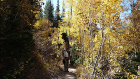
The trail description I printed out was rather brief, I didn't realize it wasn't super specific about the actual trailhead location. After a bit of confusion we finally decided to park at the upper Little Cottonwood Canyon trailhead. We hiked for about half a mile and boy it was beautiful!
 |
| Mind boggling colors along Little Cottonwood Canyon trail. |
 |
| Leaf covered trail. |
In the meantime I found another description of the trail (we carry a Nexus 7 tablet with us); this one also failed to mention the exact trailhead, but it gave more details on the trail itself. We were lucky to have found someone who knew the area.
We knew we were at the right place:
 |
| Red Pine Trail: 3 miles one way, 1,940 ft of elevation gain. |
We started up and the views were spectacular:
 |
| Looking North up Little Cottonwood Canyon, ski resorts are at the top of the canyon. |
 |
| Looking South, down Little Cottonwood Canyon, Salt Lake City is just outside the canyon opening, with the Oquirrh Mtns in the distance. |
The trail had been gentle as described, then it got steep, as described. But the steep just kept on going and going! At the trailhead Hans had started tracking our mileage with Endomondo and at this point I asked him how far we had gone: 2.5 miles. YAY, we only have half a mile to go!
The temperature was great, in the mid 50's, but overnight temps were below freezing this high up and we had a few icy spots where tiny streams took over the trail:
 |
| Ice on the trail, this is in the steep section. |
 |
| Red Pine Lake |
The steep return was hard on the knees and feet but at least we had the beauty of our surroundings to dull the pain...
 |
| Colors abound on the trail. |
 |
| Even the understory is flaming gorgeous! |
On the way home we stopped at the downtown farmers market and found some of the best produce prices I've ever encountered at a farmers market. Then we treated ourselves to a fantastic Mexican feast at Red Iguana. I can highly recommend this restaurant; the flavors were complex and delicious, the salsa was not wimpy, and we have enough leftovers for a second meal!
Lessons learned: Make sure the trail description you settle on has plenty of detail, and don't go for a lot of elevation gain when you aren't operating at 100%!

No comments:
Post a Comment