Monday, May 27, 2013

More Adventure in the Mountains North of Mancos

We were contemplating a seven mile hike at 12,000 ft elevation but nixed that idea thinking the road could still be covered in snow and didn't want to drive 25 miles to find that out.

We wanted to explore a slightly different area than a couple days ago so we headed up Fire Road 566 (the turn off for Echo Basin) just East of Mancos and made our way to the trail head for Owens Basin Trail. The hiking brochure said that this trail crosses the Mancos River and should not be attempted in the spring. But the map in the brochure did not show this trail crossing any river! We decided to just wing it, thinking we could improvise if we had to. (The description in this link is the same as my hard copy, but the map does not match.)

Anyhow, we made it to the trail head just as described and headed down the road.

It was beautiful, of course. We are in the Colorado mountains after all!
We saw many, many of these interesting looking plants that kind of remind me of Hostas.

After heading downhill for a while we came to the signed Owens Basin trail head and moments later came to the heavy flowing South Fork of the West Mancos River.


I've seen other blog posts about this hike so I know you can cross it in July or August...but we definitely weren't crossing it in May! So we headed back to the truck enjoying the gorgeous scenery all around us.


We decided to continue up FR 566 because it looked like you could make a loop drive out of it. Less than half a mile later the decent dirt road turned really rocky...but we have a 4WD truck so what the heck. Moments later we had a potential road block.


No problem at all, just move aside what you can and ease your way over it!

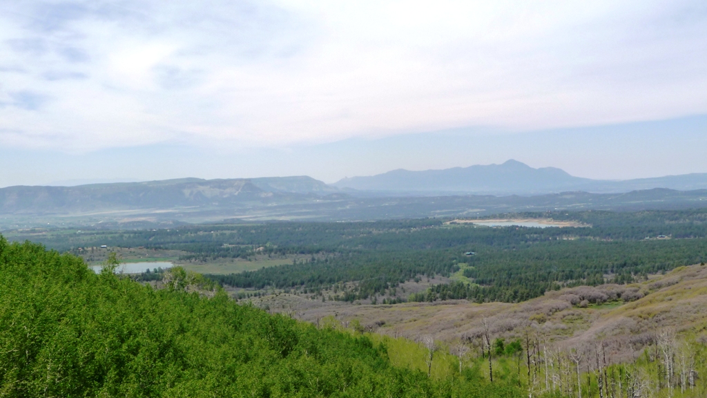
We continued on up the road, which remained quite rocky, and were treated to some amazing views. There were even some lucky tent campers on the hill opposite the incredible views below.

Looking North East

Looking South East

A couple minutes later I got to see what those Hosta-like plants look like when they bloom:

Avalanche Lilys...so pretty!

At this point we met up with a guy in a Grand Cherokee heading towards us who said he had gotten stuck in the snow just up the road and had to be pulled out by some Jeepers. Sounds like a good time to turn around! Heading back the way we came we continued to be thrilled by the beauty around us.

Snow melt streams were everywhere.
Marsh Marigolds! In two colors!

We saw more wonderful boondocking sites along the road:

Standing in one boondocking site we could see someone else enjoying their site just up the road.

And the view from the site we were standing in...
While observing these boondocking sites we noticed a trail and decided to stretch our legs...
This unmarked but well-used trail invited us to meander for a bit.
It headed off into a large stand of aspen and seemed to be an old road bed.

The trail kept heading down hill and we decided we'd gone far enough. After enjoying the view to the South West, towards Mesa Verde and our campground, we headed back towards the truck by a different route.

Clouds and haze are building over the Mancos Valley.

We bushwacked part of the way back and saw what I've since identified as bear scat (I'll spare you the photo). First time we've seen that...and while I'd love to see a bear while hiking, I also don't really want that adrenalin rush!

It was in the aspen grove, bushwacking along the stream that we saw the bear scat.

On the way back down we checked out a neat looking RV Park, Echo Basin RV Resort, that could be a good place to park (with full hookups) next time we're in the area. I'd still like to do the Indian Ridge Trail at 12,000 feet, but a little later in the year.

Sunday, May 26, 2013

Hiking Along the West Mancos River

We've been immersing ourselves in the amazing green all around us, spring is just the prettiest time to be here. The San Juan National Forest lies just North and East of Mancos, CO and the forest roads just a few miles out of town lead to some mighty fine trails.

We headed out to the Transfer Recreation Area (see Part 4 and Map 3, here) passing some amazing boondocking sites in meadows bordered by stands of quaking aspen and fir and pine. We chose to hike a five mile loop that gave us canyon and snow capped mountain views, dropping down to follow the West Fork of the Mancos River at full flow with spring runoff.

Hike specifics: We parked at the West Mancos Overlook, took the Rim Trail South, the Box Canyon Trail down to the river, then the West Mancos Trail North along the river, then the Transfer Trail back up to the truck. That was five miles, then we walked the short and easy Big Al Trail to a viewing platform providing amazing unobstructed views of the La Plata Mountains. Elevation ranged from 8900 feet to 8200 feet at the river, then back up to 8900 feet.

The river segment had some steep ups and downs when the trail had to avoid the river or some obstacle on the bank, but all in all it was a fairly easy hike, especially if you are a lucky soul who is used to higher elevations.

View from the Rim Trail. The West Mancos River goes through the canyon below us.
Taking the Box Canyon Trail down to the river, we passed through a jumble of brilliant green and white aspen.
We were ushered onto the West Mancos Trail by a lovely carpet of bright yellow.
What is this unique looking flower?
We love hiking near the sound and the rush of water.
Here the entire river is channeled between two rocks.
Back up on the rim we had lunch in this bucolic setting.
Incredible unobstructed views from the viewing platform on the Big Al Trail.
We drove on up the forest road and discovered this decommissioned fire lookout tower that can be rented for one or two night stays during the summer. Note: there is a solar toilet but it's on the ground level!

Jersey Jim Lookout
There was a forest service campground right by our parking place, but it was practically empty. I'm not sure why anyone would pay to camp with no hookups when you can camp for free anywhere along the forest road.

Plenty of big rigs boondocking up here.
More big rig space, for free!


Saturday, May 25, 2013

Exploring Mesa Verde National Park

The entrance to Mesa Verde National Park is just one half mile from our RV park so it had to be on our list of things to do while in the area. We are a bit ambivalent about our national parks. They do indeed protect some of the loveliest and most interesting sights in the country but they also draw some of the biggest crowds. We decided to visit the park before the holiday weekend began, hoping to avoid some of the crowds we anticipated would visit over the next few days.

Mesa Verde preserves sites of the Ancestral Puebloans. They lived in the area starting about 1400 years ago, for about 700 years, starting out on the mesa tops and eventually building dwellings using natural caves in the cliff sides. They inhabited the cliff dwellings during the 13th century and then left the area for reasons unknown.

The park is huge. It is easily 25 miles long, with many sites to stop and visit, and several of the sites can be visited only by ranger-led tours. We decided to do two ranger tours: Cliff Palace and Balcony House, preceded by the Petroglyph Point hike and exploring the self-guided Spruce Tree House cliff dwelling.

There is a beautiful new visitor center where the staff can help you plan how to spend your day and where you buy tickets ($3/each) for any ranger-guided tours.

Here's a look at our day in Mesa Verde. The crowds were not too bad for the most part, the guided tours were informative and pretty interesting (Balcony House more so than Cliff Palace, in my opinion), and there was lots of driving involved (we didn't know how huge the place was before we arrived).

Gorgeous, brand-new visitor center.

The ranger who helped us plan our day said the Petroglyph Point hike was her favorite in the park and it did not disappoint. The trail hugs the wall of the canyon just below the rim, allowing excellent views and winding through some interesting geology. You might have trouble with this hike if you have a fear of heights.

Yes, that is the trail!
Skinny, uneven, stone steps through the rocks...fun!

Vultures warming up in the sun.
Remains of a small cliff dwelling along the trail.
The canyon we were skirting.


Back at the trail head, we headed down into the canyon a short distance to see the Spruce Tree House. This cliff dwelling has 114 rooms and was constructed between 1200 and 1276 and is thought to have housed about 100 people. It is about 95% original construction.

Spruce Tree House from the canyon rim.
A little closer view.

After walking through Spruce Tree House among a lot of people, we drove further into the park to the Cliff Palace in time for our 12:30 tour. The park service allows about 50 people on this tour and tours depart every half hour each day. Cliff Palace is so named because it is the largest cliff dwelling in the park, it is about 85% original construction. There are some steep stairs and ladders on this tour.

View of Cliff Palace from the canyon rim.
Here you can see how the dwellings are built around large sections of existing rock in the cliff.

We then drove on to our next tour of Balcony House. Along the way are pull outs so you can view dwellings in the cliff walls across the canyon. There are over 600 cliff dwellings in the park and only a handful are open to the public.


Balcony House was a unique tour. Not only did you access it via steep stairs and a very long ladder, you also walk through a small passage way and leave by crawling through a tunnel. This tour is not recommended for people with a fear of heights.

This dwelling is divided into two halves; this North half has a wall surrounding the courtyard,
an unusual feature we had not seen in other dwellings which usually just open right onto the canyon.
One of the balconies for which the site is named is in the right foreground supported by logs.
We took the ladder up to the passageway (that dark hole) to the other half of the dwelling.
Opposite view of the North side of the dwelling.
We entered the dwelling through a small passageway behind the stacked rooms.
Those people are looking through the doors into the rooms.
A view into the South side of the dwelling which has two round kivas and showed evidence of fires,
unlike the North side.  
Looking back towards the North room you can see how precipitously the canyon drops away,
there is no protective barrier on this side. This dwelling was unique due to the large amount of
retaining walls that had to be built in order to construct all of the rooms in the cliff.

The passageway and tunnel features of this dwelling suggested a need for security. Here is the exit tunnel:


Hans entering the tunnel.

The exit was a little larger than the entrance and you could stand up in the middle of the tunnel.

On our way out of the park we stopped to take in the view to the North West.