Showing posts with label Colorado. Show all posts

Sunday, October 11, 2015

A Relaxing Stay at Ridgway State Park

We've spent the past week at beautiful Ridgway State Park, just a few miles north of the laid back town of Ridgway and a few miles further to lovely Ouray, CO, a town where we spent two weeks in June 2013.

Our arrival in the area coincided with the last evening before our hiking buddies Mark and Bobbie, of Box Canyon Blog fame, departed for points south west. We caught up over pizza and drinks and said goodbye with the possibility of our paths crossing again in the desert.

Our stay in 2013 included numerous strenuous but incredibly beautiful high altitude hikes in the San Juan Mountains, blog posts related to those adventures can be found starting here.

This time we found ourselves feeling not very enthusiastic about hiking relentlessly steep trails starting at about 9,000 feet or more. That lack of enthusiasm combined with our trucks "check engine" light suddenly glaring at us from the dashboard had us limiting our driving and meant we had a relatively relaxing stay at Ridgway without any extreme hiking on the agenda.

Before that check engine light threw a damper on things we did a short hike on the Dexter Creek Trail. Like every trail around here (except the Uncompahgre River Trail) this one goes up pretty steadily with the distraction of a couple of interesting mine ruins. Unfortunately rain turned us back after 1.5 miles.


Pockets of color pop on the mountainsides,
remnants of the seasons first snow two nights before cling to the peaks.

Mining ruins dot the landscape in these parts, this one clings precariously to the hillside.


We took a day trip to Telluride, CO. The ritzy ski town sits in a gorgeous box canyon surrounded by freshly snow capped peaks and splashes of autumn color. We started our visit with a short but steep (of course!) hike on the Jud Weibe Trail. It's a serious workout with fantastic views of town and the surrounding mountains.

I am amazed that an expensive town such as this has a FREE gondola that takes us up the mountain to the ski area and over the top to the neighboring town of Mountain Village. The views are gorgeous!


A great view of Telluride from our lunch spot atop the mountain.

Telluride is a pretty place for a stroll.

On our drive home from Telluride the check engine light came on, indicating a potential problem with our Emissions Control System (ECS). With only 500 miles remaining on our ECS warranty we decided to limit our driving during the rest of our stay and made an appointment for our truck upon our arrival in Moab next week.

With Ouray a short drive from our campground we knew we had to hike the Perimeter Trail again. This five mile trail almost circles the entire town and offers up terrific views of this idyllic place. Even though we'd hiked it a couple of times during our previous stay, we still lost the trail at a confusing, poorly signed intersection; fortunately it is impossible to get lost with the town so close by!

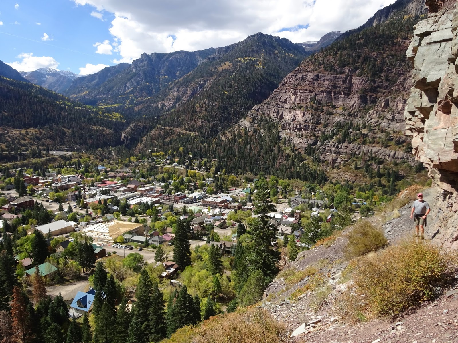
Lovely Ouray in her Switzerland-like setting.

Small bear tracks seen on the Perimeter Trail.

Campground Review

Ridgway State Park has three different campgrounds to choose from, though options are limited in October. We stayed in the North campground, Pa-Co-Chu-Puk (Ute for Cow Creek), the only full hookup campground in the park. In October all sites are first come, first serve and if you arrive during the week you must go to the main park office (several miles down the road) to pay for your site.

We chose a site overlooking the Uncompahgre River, which is also the loop furthest from the highway. We'd heard internet signal could be iffy in this campground, but we had decent Verizon signal with our booster (2 - 3 bars of 4G).

Roads are paved, sites are concrete, picnic table, BBQ and fire pit at each site. Our site also had a tent pad. Some sites have a shade ramada over the picnic table. Most sites are pullouts, a few are back in, all looked nice and level. Site separation is good. It is very quiet at night.

Fishing is good here according to everyone we asked. There are two ponds where fish can be caught and kept based on Colorado fishing laws; fishing in the adjacent Uncompahgre River is catch and release only.

PS: We can highly recommend the crazy, unique, yet totally delicious tacos at Tacos Del Gnar in Ridgway!

View of Pa-Co-Chu-Puk campground from the Enchanted Mesa Trail.
The loop on the right is close to the highway and the noisy cattle guard at the park entrance.
We stayed in the loop at the center of the photo in a site overlooking the river.

Site 278, the river is just below us.

View from inside our RV.

View of our RV from across the river at the walk-in tent area.
Notice the fishermen in the river.


Rosie liked this park!

We often saw deer in the evening or early morning.

View of the mountains to the East, whose flanks are covered with colorful aspen, from the Enchanted Mesa Trail.
Notice the line of sheep across the grass.

Tomorrow we'll be on the road early to Moab where we'll drop our rig at Portal RV Park, then head straight to the Chevy dealer to take care of that check engine light.


Tuesday, October 6, 2015

Adventures Around Fruita, CO

Fruita, CO is well known as a mountain biking destination, second only perhaps to Moab, but we didn't even unload our bikes during our week long stay in the area. We're finding more and more that we prefer getting up close and personal with the landscape on foot, the better to enjoy the wildlife, geology and plant life instead of whizzing by it all on two wheels.

Fruita is next door neighbor to Grand Junction, CO, a town that Hans spent several formative years growing up in and we were able to enjoy visits with old friends from his distant past. Jay and Nancy had us over for dinner one evening and gifted us with a bounty of cherry tomatoes that really put a smile on my face!

As usual, hiking was foremost on our agenda and the options available in this area are numerous. Our buddies John and Pam had scouted out a couple of trails during their visit in May and our first hike was a reverse of the Monument/Wedding Canyon hike they had done. We chose to go up Wedding Canyon to get the steepest part over with early (and uphill instead of down) as well as to take advantage of the morning shade cast by the canyon walls...it's been hot in western Colorado!

Almost full moon sinking into the West just before the morning sun hits the canyon walls.

As we neared the top of Wedding Canyon we could see sandstone monoliths struck by morning sun in the canyon ahead of us.

I love the tower at the end of each sandstone bench!

Happy Birthday Hans!

Colorado National Monument lies immediately south of Fruita and Grand Junction, and in fact, our hike had taken us onto Monument land. Now it was time to drive the 23 mile Rim Rock Road to get a birds eye view of the amazing sandstone canyons that make up this national treasure.

Dramatic sandstone canyons are the focus of Colorado National Monument.

Independence Monument...the monolith we posed in front of for Hans' Birthday photo!

McInnis Canyons National Conservation Area was just minutes from our campsite at James M. Robb State Park in Fruita. With miles of trails from multiple trailheads, it is an easy choice for no hassle hiking among colorful sandstone formations. On our first foray into this park we did a great six mile loop from the Devil's Canyon trailhead that took us along the base of the formations and over the top for views into the canyons using the D4 and D5 trails.

Stripey!


For our second hike at McInnis Canyons we hiked Devil's Canyon itself (trail D3). Taking the trail up canyon we chose to return by boulder scrambling through the bottom of the canyon for a challenging seven mile hike that had us climbing rock faces to go around water-filled potholes and tall pour-overs!

Trail D3 starts out in the pretty canyon bottom before heading up on the bench overlooking the canyon.

As the trail climbed out of the canyon bottom the views opened up and we saw figures hiding in the canyon walls.

Making our way down canyon...
several times we had to scale the canyon walls to get around pools of water or steep drop offs.

Coming down the canyon wall after avoiding a water filled hole.

We played the Riverbend Park disc golf course in Palisade, CO one day. This long, narrow park is situated on a strip of land between the Colorado River and one of the many canals flowing through the area. Palisade is a pretty area known for the peaches and grapes grown here.

The course alternated between treed sections...

...and wide open spaces.
Those are the Book Cliffs behind Hans, they make up the northern border of the entire Grand Valley.

Downtown Grand Junction is nicely done, with wide sidewalks full of plants and art and seating.
We especially liked the mountain biking art.


We hiked a second trail recommended by John and Pam, the Liberty Cap/Corkscrew Loop. Parts of this loop are very steep and rocky, those with a fear of heights need to be aware there are some places with extreme exposure to steep drop offs.

From the trailhead we could see Liberty Cap as a tiny rounded point on the left atop the sandstone way above us.

Good use of natural surface for the trail.

That's Liberty Cap behind Hans.


The wind howling through this canyon threatened to blow us off the top!

Great views of the Grand Valley.
Those are the Book Cliffs on the far side of the valley.

We had a fun evening with Hans' childhood friend, Doug and his wife Penny and kids Sarah and Chad. Good pizza and beer at Hot Tomato Cafe in Fruita, then a campfire back at our site. It was great reconnecting with folks from Hans' past, learning about the evolution of this area and their lives over the decades and sharing our adventures on the road.

Hans serenades Chad, Penny, Doug and Sarah.

Campground Review

We spent a week at James M. Robb State Park, once again using the Colorado State Parks Pass that we purchased last spring in order to avoid the $7 per day fee they want to tack on top of your nightly camping fee. This state park has five sections along the Colorado River in the Grand Valley, two of those sections offer camping, we stayed at the Fruita site.

Like all of the other CO state parks we've stayed in this year, this park is very well maintained (that $7 daily fee at work). Roads and sites are paved, picnic tables with ramadas and fire pits at each site. Nice restroom/shower buildings and inexpensive laundry on site. This park has a playground and access to the Colorado River and a couple of small lakes.

We had excellent 4G Verizon signal, no booster necessary. The park is right on the edge of Fruita and minutes from Grand Junction so shopping is plentiful, trails are bountiful and nearby. The only drawback here was some freeway noise as I-70 is less than half a mile away, and occasional train whistles.

Site #38 had excellent privacy.
All full hookup sites at the Fruita park are pull outs.

From the little mound where the previous photo was taken I could see one of the small lakes.

Rosie liked this park very much!

Sunset from our site.

We delayed our departure from Fruita for a day due to rain, so today we're off to Ridgway, CO.

Sunday, October 4, 2015

The Arches of Rattlesnake Canyon

Rattlesnake Canyon is said to have the highest concentration of arches in the nation outside of Arches National Park, but is not easy to reach, all three options pose challenges. For one, a short drive from Fruita, CO to the Pollack Bench trailhead begins a strenuous round trip hike of at least 15 miles. Another option is a five mile RT trail that can only be accessed directly from the Colorado River.

We chose the six mile RT hike accessible from the Rattlesnake Canyon trailhead...via an 11 mile drive through Colorado National Monument then a 13 mile drive down a narrow dirt road with very few wide places for passing. The last two miles of the dirt road is rough, with big enough boulders and drop offs that we chose to park about a mile from the trailhead and walk the rest of the way.

But first, as we made our way through Colorado National Monument on the way to the trailhead a chance sighting brought us to a screeching halt...

What a way to start the day!

He seems to be watching the sunrise on one side and keeping an eye his harem across the road below.

Can you see the five bighorn sheep in this shot?


As the sun came over the sandstone bluff this beautiful apparition moved on and so did we. The dirt road to the trailhead was had us gritting our teeth, hoping we'd not meet up with anyone coming out and, near the end, hoping we'd find a big enough turn around and parking place when the road seemed too rough to continue.

From our parking spot about a mile from the trailhead we had a great view into Rattlesnake Canyon,
so named for its curvy lines, not its abundance of snakes.
It turns out the arches are in the top layer of sandstone on the right,
we did not have to go to the bottom of the canyon, we hiked on the top bench.

We saw an arch across the canyon, and it wasn't even part of the arch hike!

This beautiful juniper skeleton frames potential future arches across Rattlesnake Canyon.

From the trailhead we hiked about two miles or so before we came to the first of the arches...
well actually three arches at once!

As we walked along the bench arches would appear seemingly around every corner!

From our position on the bench we could look down into the canyon to admire the fragile looking spires below.

Often we could not see an arch until we passed the alcove.


Even without an arch the sandstone formations were amazing.

The last arch was substantial.

I'd read that if you could scale the last arch you could make the hike a loop by connecting with the overlook trail above...
we tried, but there was not a chance for us, it's way too steep!


As we hiked back past each arch we caught a person peering into an arch on the overlook trail above us!


Pinion Pine nuts!

This was a fantastic day on the trail, worth it if you have a vehicle that can make the drive (it's those last two miles that is the problem). We did meet three vehicles on the drive out, fortunately with small places to just barely get past each other! We'd been warned not to drive the road if there was a possibility of rain, this soil turns slick at the slightest bit of water and we were lucky there too...an unexpected cloud burst later in the afternoon could have stranded us out there!

This was our last full day in Fruita, CO, stay tuned for a wrap up of the many trails we hiked in the past week. Tomorrow, weather permitting, we're off to Ridgway CO.