Tuesday, October 31, 2017

Volcanic Fissures and a Subalpine Lake near Lee Vining, CA

Lee Vining, CA is perched on the edge of Mono Lake and serves as the eastern gateway to Yosemite National Park. We last spent a few nights here in October 2014; this time was another short stay, just two nights but we managed to pack in some very diverse hikes in such a sort time frame.

We arrived at Mono Vista RV Park just a few nights before they would close for the season (on Nov. 1st). A nice little RV park, it is just down the street from the Mono Basin Scenic Area Visitor Center.
There we found the lovely creek trail we'd hiked on our last visit had been washed out by the raging snow melt this past winter so our post-drive leg stretcher hike was a sandy trek down to the lake shore instead.

Mono Lake is a large shallow lake with no outlet so it is highly saline and alkaline. The flies and brine shrimp that thrive there feed many thousands of birds on their annual migration. From 1941 to 1990 water was diverted from the streams feeding Mono Lake and the water level dropped 45 feet endangering this fragile ecosystem.

In 1994 a lawsuit determined that the lake must be allowed to recover to 20 feet above its lowest level. Fortunately the heavy rains and snow pack this past winter is helping to reach that goal, though there is still a long ways to go, it was good to see much more water in the lake than we'd seen in 2014.

Wetlands and tufas around Mono Lake.
The low black hill on the opposite shore is Black Point, an ancient underwater eruption...
we will climb that tomorrow.

Tufa are limestone columns formed long ago by calcium rich underwater springs when the lake was much deeper.

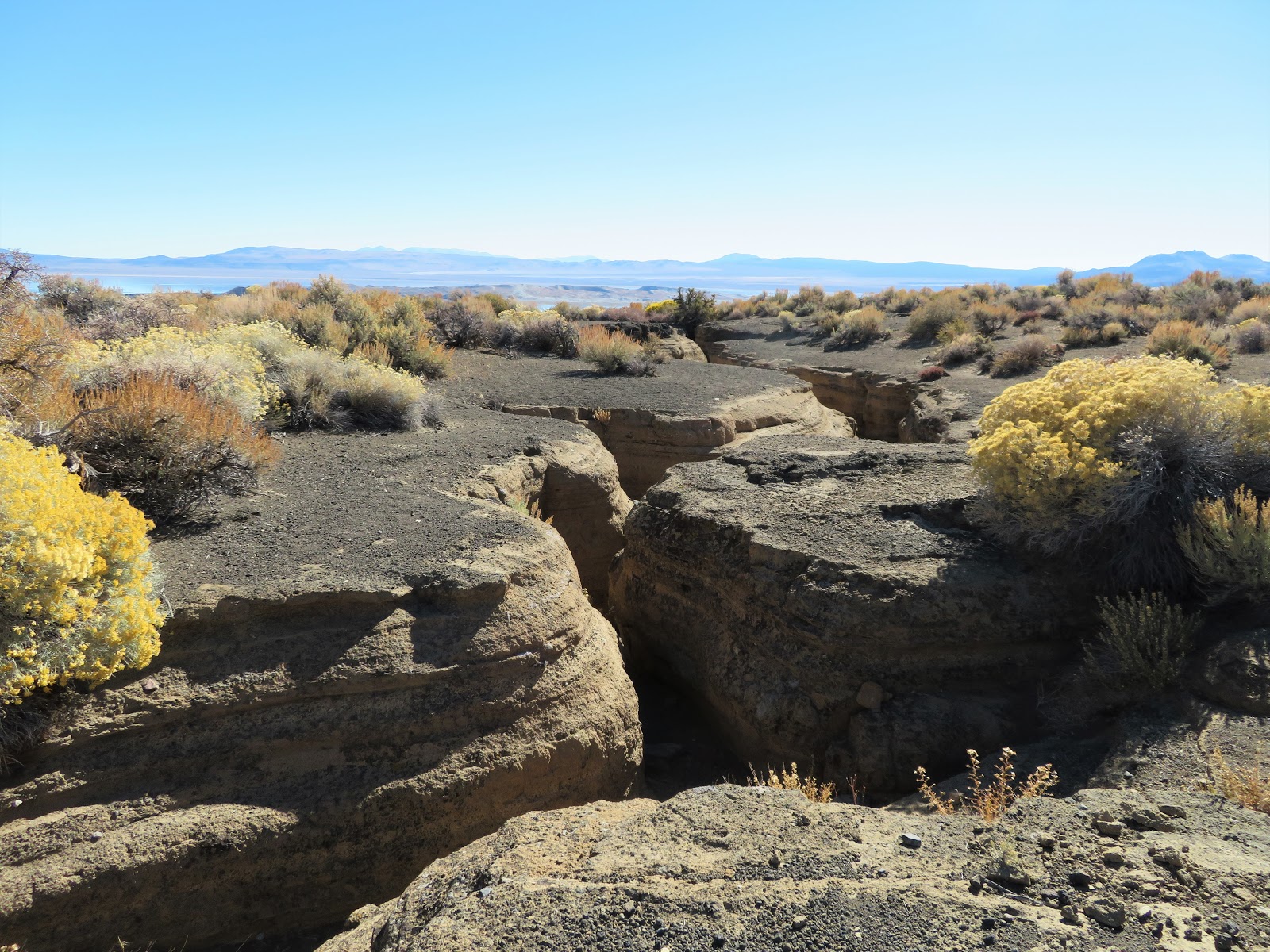
We began our one full day in Lee Vining with a hike to the Black Point Fissures. This small hill on the north edge of Mono Lake erupted underwater thousands of years ago and the fissures were created by the rapid cooling. There is no official trail, just head up the loose black cinder hill towards the top and continue past the high point until you come across the fissures.

Loose, black sand-like cinders make the climb into a workout.

The fissures are similar to slot canyons we've seen elsewhere in the west.

I thought this was a neat hike, it's about three miles round trip with a treasure hunt feel as you search for the fissures.
Not everyone will like the deep cinders and all the bushwacking involved.

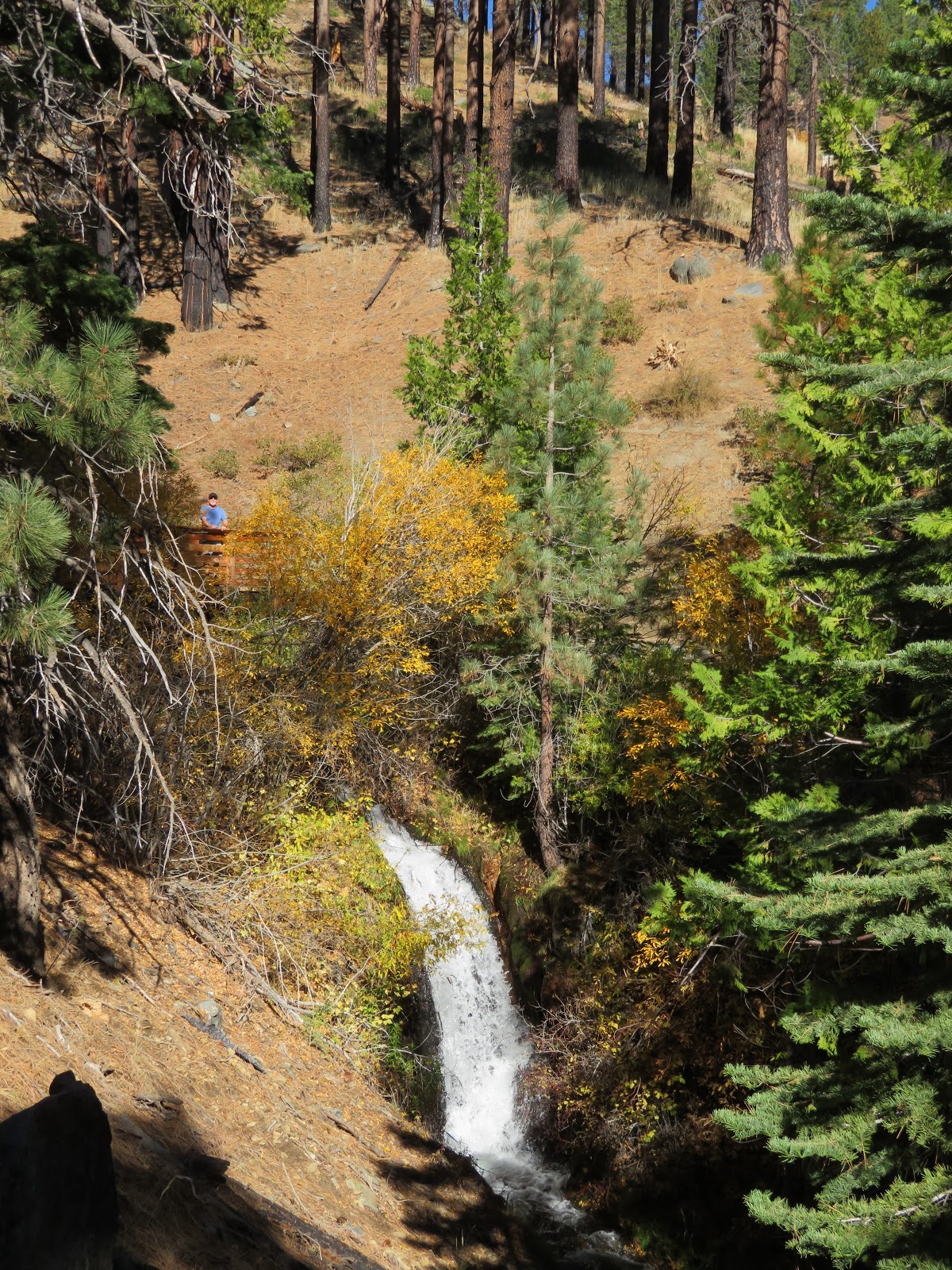
Making the most of our limited time in the area our second hike for the day was to Parker Lake, a trail we'd learned about from Hans' brother, Norm. The trailhead is located up a short dirt road off of June Lake Loop.

This was a gorgeous trail! The long distance views, both back towards Mono Lake, and ahead into the towering Sierra Nevada mountains, the burbling creek, the enormous Ponderosa Pines, all served to take our minds off the fact we were hiking up at 8,000 feet!

The trail starts climbing gently right away,
the views behind us to Mono Lake and various volcanic mountains were beautiful.

Parker Creek burbled away in the canyon to our right and the Sierras loomed ahead of us.

Lively Parker Creek accompanied us through the second half of the trail.

We saw numerous decent sized trout, both in the creek and the lake.

Parker Lake did not disappoint.

We decided to try to circle the lake.
The going got a little rough at the far end but we made it all the way around.

The big pile of sticks at bottom right is a beaver lodge.
The water was so clear it was tempting to sit and watch until a beaver emerged!

Creek crossing.

There are endless adventures to be found around Lee Vining, one full day just barely scratches the surface. But we've got places to be...onward!


Wednesday, October 25, 2017

Autumn in Carson City

We had a very enjoyable 10 day stay in Carson City, NV in May of 2014 when we discovered there is a very active trail building community here. This last stay was no different, in one week we hiked a new-to-us trail almost every day, with the added bonus of some lovely fall color.

The Bently Heritage Trail is a flat, easy walk through the Carson River floodplain, sometimes along the river. The Nature Conservancy worked with the property owner to demonstrate that habitat protection, cattle ranching and public access can coexist. Horses, bikes and dogs are not allowed on this trail system. While not the most exciting place to hike, there is bird watching (we saw numerous Northern Harriers) and long distance views galore.

The Carson Range, a spur of the Sierra Nevada Range, stands between Carson Valley and Lake Tahoe.
Grasses, sagebrush and a few giant cottonwoods grace the Bently Heritage trail system.

Subtle autumn colors stretch across the valley.

Just a few miles over the mountain from Carson City, Skunk Harbor is an easy walk 564 feet down an old fire road to a gorgeous bay on Lake Tahoe. There's an old abandoned summer house built in the 1920's and potential wildlife watching. We saw bear tracks, a couple of bald eagles and a mink! Top that off with complete solitude and it was a perfect day on the trail.

Built in 1923, the Newhall House was a retreat for a wealthy San Francisco family.

The house looks out on this stunning bay.

Bear tracks along Lake Tahoe.

We sat still enjoying the scenery long enough that a mink decided we weren't a threat!

Sorry for the blurry photos...it moved quickly!

The mink was so curious about us it swam over to get a closer look!

It got within five feet of us, probably hoping for a handout.

Newhall house peeks out from autumn finery on the shores of Lake Tahoe.

The western edge of Carson City nestles up to the foothills of the Carson Range so for many folks hitting the trails is as easy as walking west from their front door. Ash Canyon is just such a place where miles of trails and dirt roads head right up into the mountains...some roads will lead you all the way to Lake Tahoe!

A beautiful fall morning in Ash Canyon, home of a year round creek and trails and roads
leading all the way over the mountains to Lake Tahoe.

Another trail system right in town is Prison Hill Recreation Area. This 2,500 acre recreation area adjacent to the local prison has two sections, the northern parcel has miles of trails for non motorized use and the southern portion is for off road vehicles. The cool thing about this hiking area is the variety of terrain...you can walk for miles along the Carson River and the Mexican Ditch (built in the 1860's to power a mill and irrigate the land), or climb some serious hills providing great views of Carson City.

At Prison Hill Recreation Area we chose an easy morning walk along the Carson River and a couple of miles
worth of brilliant yellow cottonwoods.
Here, we had nice reflections on the pond dammed to divert flow into the Mexican Ditch.

There is a seven mile trail that connects Ash and Kings Canyons on the western edge of Carson City, it's got plenty of elevation gain so is best done as a shuttle hike or bike which doesn't work for us since we have just one vehicle. Having hiked at the Ash Canyon end already, we chose a 4.5 mile loop at the Kings Canyon end for our final hike in the area. The Upper Waterfall Loop provides great long distance views of the Carson Valley as well as a couple of waterfalls.

A pop of colorful aspen among the Ponderosa.

Upper waterfall.

Looking down King's Canyon into Carson City.

Carson City has some beautiful historic homes adjacent to downtown so it's always pleasant to take a stroll through the neighborhoods. I didn't get any photos but there was a bounty of fall colors as the trees were at peak color in all the neighborhoods we walked. What I did photograph was some of the Halloween decorations currently on display...

Do you dare enter???


Built in the early 1900's, the Governor's Mansion is an iconic historic building...all decked out for Halloween.

Spooky!

Once again we stayed at Camp-N-Town, a basic urban RV park that is convenient to everything in Carson City. Roads are paved, sites are gravel and there are quite a lot of permanent rigs, though they are reasonably tidy. One of the best things about this location is right across the street, the amazing Pho Country Vietnamese restaurant. The Pho is out of this world!

Mmmm Mmmm Good, Pho Country!

Next up: a couple of nights in Lee Vining, CA.

Tuesday, October 17, 2017

Escaping the California Wildfires, But Not the Smoke

Fleeing the California wildfires we continued east into Nevada. We'd originally planned to stay in tiny Verdi just across the Nevada border, but Hans had been monitoring the forecast and when the overnight temps were going to be in the low 20's we decided to stay at Sparks Marina RV Park where it was only supposed to get down to 30.

We've stayed at Sparks Marina before, it is an average urban RV park. Everything is paved, sites are pretty close together, and there is fake grass instead of the real stuff (which I find weird, Rosie doesn't like it either). The park is convenient for getting around Reno/Sparks and there is a nice two mile walk around the adjacent Sparks Marina Park Lake.

On our second day in town smoke from the California fires spread into the area and hung heavy over the entire valley, worsening as the day wore on. Our only outing was to the lovely Rancho San Rafael Regional Park and a walk through its beautiful Wilbur D. May Arboretum.

Many lovely spots to sit and enjoy the colorful views in Wilbur D. May Arboretum, even on a smokey day.


Out of hundreds of geese in Rancho San Rafael park, we saw two with this odd head coloration.

On this stay in Reno/Sparks we managed to do several new-to-us trails. The first was brought to our attention by John and Pam; we love getting trail ideas from fellow hiking full timers! The Rubicon Trail was a gorgeous 9.2 mile out and back hike along the SW shore of Lake Tahoe between DL Bliss State Park and the lovely Vikingsholm. Though longish, the trail is easy with only a few gently rolling hills.

Looking north over Lake Tahoe the smoke haze is not too bad.

The smoke haze is a little worse looking south and would continue to worsen as the day progressed.

Peaceful cove.

Critter sighting of the day.

Vikingsholm is a gorgeous Scandinavian themed summer home built for Mrs. Lora Josephine Knight in 1929 by her Swedish nephew.

This is a stunningly detailed structure.
It has a large round turret around the left side and the entire one story back portion of the house has a sod roof.

Intricate carvings on most of the wood.

Mrs Knight's tea house sits atop a small island in the middle of Emerald Bay opposite Vikingsholm.

A really big Ponderosa...and yes, it was cool when the wind was blowing,
just the kind of hiking weather we love!

Brown's Creek Trail is a nice 4.7 mile lollipop loop in south west Reno. This dog friendly trail has long gentle ups and downs with some nice views, a year round creek, spring flowers and fall foliage.

The Virginia Hills provide our distant view as we drop into Brown's Creek canyon.

Aspens provide a bright splash of color along the bottom of the creek bed below the trail.

Ponderosas tower over a young stand of aspen.


It's been cold overnight!

For our last hike in the area we headed west towards Truckee and Donner Summit to hike Mt Judah Loop. This 5.6 mile lollipop loop includes a short section of the Pacific Crest Trail and gains and loses 1,228 feet, topping out on Mt Judah at 8,216'. It's a solidly moderate hike, nothing is too steep, but we definitely felt the elevation having spent the summer at sea level.

Looking back along the ridge we walked to gain the summit.
Donner Peak is on the right and can be summited from a spur trail off the Mt Judah Loop.

Donner Peak on the left and Donner Lake below.
Smoke haze blankets the distant hills.

Even though the Ponderosa forest was very dry, the trees sported some impressive moss!

It was a fun week in Reno. We had a good visit with a friend who is considering the RV lifestyle and we enjoyed sharing some of the knowledge we have gained from five years on the road. Wishing you luck and perseverance Billy, as you work towards your goals!

Next up: a week in Carson City...