The
Sand Canyon Trail is located within
Canyons of the Ancients National Monument. The trail is about 6.5 miles long (plus side trails) and is bounded on the North by the site of the Sand Canyon Pueblo which originally held 420 rooms, 100 kivas and 14 towers but is now mostly piles of rubble with interpretive signs. We chose to hike from the South access point, County Road G, 12 miles West of Cortez, CO.
We learned about this trail from a very helpful woman at the Mancos Visitor Center, who told us it was her favorite hike in the area. Boy, was that a good tip because this was a superb hike that served up the fun of searching for multiple cliff dwelling ruins, interesting rock formations, several collared lizards and lots of blooming flowers. Binoculars are a good idea for this hike as you are constantly searching near and far for ruins.
We hiked just shy of 11 miles, under somewhat overcast skies, at about 5500 ft elevation, with short up and down segments with no great elevation changes. There are many short spur trails along the way that take you close to the ruins. There is a map at the trail head and decent signage along the way. There was also a brochure at the trail head with a good map of the trail system.
Hike details: We hiked the main Sand Canyon trail, plus all the spur trails, until we reached the point where the trail climbs up the mesa (about 4 miles in). We returned the same way, until we reached the East Rock Creek Connector trail, then left on East Rock Creek trail, then took another Connector trail (unmarked) back to the main trail head.
We hiked mid-week and only ran into two hikers, two horseback riders and one mountain biker. This trail system has become popular with mountain bikers and is probably pretty busy on the weekends. Personally I would rather bike at Phil's World and hike these trails.
This hike ranks up there as one of our favorite hikes we've ever done! AND, there are more trails we didn't have time or stamina for in the area...which means we have something to come back for. I took over 250 photos and had a heck of a time weeding them down to just a few that would tell the story of this hike; I hope you enjoy the highlights of our day in the land of the Ancients!
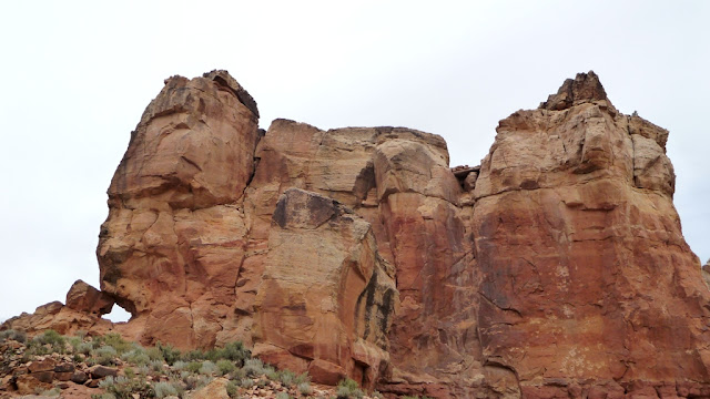 |
| Castle Rock towers over the trail head. |
 |
A 40-room pueblo was built around Castle Rock, though very little remains of it today.
At the top of the rock you can see a wooden platform and small remains of a wall. |
 |
| Lavender was the color of the day! |
 |
| As we headed up canyon, on our left were fabulous sandstone formations. |
 |
| Within the first half mile the first cliff dwelling was sighted. |
 |
| Approaching Saddlehorn Pueblo. |
 |
| If you don't want to hike far this ruin is also in the first mile of the trail. |
 |
| The right side of the trail gave us views into huge canyons and out to the distant mountains. |
 |
| Two shelves of ruins here. |
 |
| And another two shelf site. |
 |
| We spied this alcove ruin across the canyon a good half mile away. |
 |
| Kiva on the mesa top. |
 |
| We saw about a half dozen Collared Lizards. |
 |
| Pile of pot shards. |
 |
| Seen across the canyon. |
 |
| In giant Rock Creek Canyon a number of smaller sandstone canyons converge. |
 |
| Evidence of ruins on the top right rock. |


Wow!
ReplyDeleteLooks just like Cedar Mesa!! Finding the ruins is so much fun. I like the ones you can get into. Great hike!
ReplyDeleteThe pincushion cactus are really blooming.
I love when the desert is in bloom. Amazing country and great photos!
ReplyDeleteThis hike looks fabulous. I will certainly have this on our agenda next time we are out west. Have fun guys!!!
ReplyDelete